
Aurora borealis / Northern lights seen from Mt Horeb, Wisconsin, September 28, 2017
After moving to Wisconsin from Chicago several years ago, I was on a mission to try to see the Northern Lights. As much as I love Chicago, you can barely see stars there, let alone aurora. It was time to take advantage of getting a little further north (better for aurora viewing) and now dark skies were only 30 minutes away instead of 2+ hours.
It took several attempts to finally see the Northern Lights, but I finally had some success. More often than not, though, either clouds obscured the view, the show didn’t make it this far south, or I was too early/late getting out to see it.
Space weather is even more fickle than the clouds and rain we usually think of as ‘weather,’ so persistence is key for those of us in the “middle latitudes” who want to see the aurora.
These online resources were also really helpful on my quest to see the aurora:
- NOAA’s Space Weather Prediction Center
- SWPC’s front page provides a good quick look at current conditions, including the current storm level. During the geomagnetic storms that give us the Northern Lights, SWPC staff often post updates at the top of the page.
-

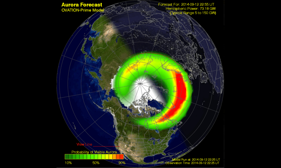
An example of SWPC’s Ovation Auroral Forecast
OVATION Auroral Forecast – SWPC’s OVATION forecast is more of a ‘nowcast’ — the map shows you where the aurora is now. The map’s ‘view line’ shows where the aurora may be visible, but can be a little conservative. There have been times where the ‘view line’ is in southern Ontario, but pictures pour in from the midwest. So, even if you are south of the line, the aurora may still be visible — go take a look!
- NOAA Space Weather scales — So, for example, if NOAA says there’s currently a G2 level geomagnetic storm in progress, with the possibility of a G3 level storm tonight — what’s a G2 or G3 level storm mean? NOAA’s Space Weather Scales lay it out, with examples of how far south the aurora may be visible. For example, in a G2 level storm, aurora may be visible as far south as New York & Idaho (and Wisconsin!). With a G3 storm, it could be visible even further south.
- SWPC Product Subscription Service — You can sign up to receive email alerts of geomagnetic storms from SWPC. There are many different alert types that you can subscribe to, but some particularly useful ones are the WATCH and WARNING alerts for G2 or greater geomagnetic storms. The SWPC email alerts have given me a heads-up of geomagnetic storming and allowed me to see (and photograph) the northern lights.
- SpaceWeather.com — This is a great place to go for space weather news. The site also features a photo gallery full of the latest beautiful aurora pictures from users around the world. SpaceWeather.com also offers an alert service that you can subscribe to (for a fee) to receive aurora alerts.
- SpaceWeatherLive.com
- Twitter is another great resource for aurora news. Some of my favorite Twitter feeds for Aurora news:
Good luck on your own aurora quest!

